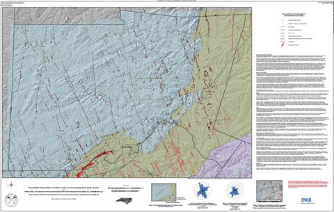
This Groundwater Features Map presents the approximate locations of geologic features that were identified during geologic mapping activities in Chatham County by the North Carolina
Geological Survey (Bradley etal., 2022). The geologic mapping identified multiple geologic structures in the map area that are collectively interpreted as Groundwater Features.
Chatham County has abundant bedrock fractures. Groundwater is present in these fractures and ground water is one of the main sources of potable water countywide. A Groundwater
Feature, as designated on this map, maybe a zone of increased bedrock fracture sand may therefore be zones of increased groundwater flow. The Groundwater Feature may have
important ramifications to ground water availability and pollutant transport. This map is a tool for ground water professionals, county staff, land owners, well drillers and other stakeholders
to assist in their various decision-making processes as it pertains to groundwater issues. Approximate size of map - 66" x 42".Approximate scale - 1:50,000.
By Phil Bradley and Richard E. Bolich.
2022.
|