![Click to enlarge](https://s.turbifycdn.com/aah/yhst-944330562336873172247019/geologic-map-of-the-goldston-7-5-minute-quadrangle-chatham-lee-and-moore-counties-north-carolina-ncgs-open-file-report-2020-06-23.gif)
![Geologic Map of the GOLDSTON 7.5-minute Quadrangle, <BR>Chatham, Lee and Moore Counties, North Carolina <br>NCGS Open File Report 2020-06](https://s.turbifycdn.com/aah/yhst-944330562336873172247019/geologic-map-of-the-goldston-7-5-minute-quadrangle-chatham-lee-and-moore-counties-north-carolina-ncgs-open-file-report-2020-06-24.gif)
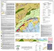
The geologic map for the Goldston quadrangle has been created as a general-purpose map that is applicable to land-related investigations in the earth, environmental and biological sciences. Includes three stereonets and a rose diagram, one cross section, a correlation diagram, rock unit descriptions and a traverse map.
By Aaron K. Rice, Philip J. Bradley, David A. Grimley and William B. Blocher. Approximate scale - 1:24,000 scale. Map size - 42" x 40". 2020
|