![Click to enlarge](https://s.turbifycdn.com/aah/yhst-944330562336873172247019/geologic-map-of-the-orange-county-and-adjacent-portions-of-the-bynum-7-5-minute-quadrangle-orange-chatham-and-alamance-counties-north-carolina-ncgs-open-file-report-2011-07-22.gif)
![Geologic Map of the Orange County and Adjacent Portions of the<br>BYNUM 7.5-minute Quadrangle, Orange, Chatham and Alamance<br>Counties, North Carolina<br>NCGS Open File Report 2011-07](https://s.turbifycdn.com/aah/yhst-944330562336873172247019/geologic-map-of-the-orange-county-and-adjacent-portions-of-the-bynum-7-5-minute-quadrangle-orange-chatham-and-alamance-counties-north-carolina-ncgs-open-file-report-2011-07-23.gif)
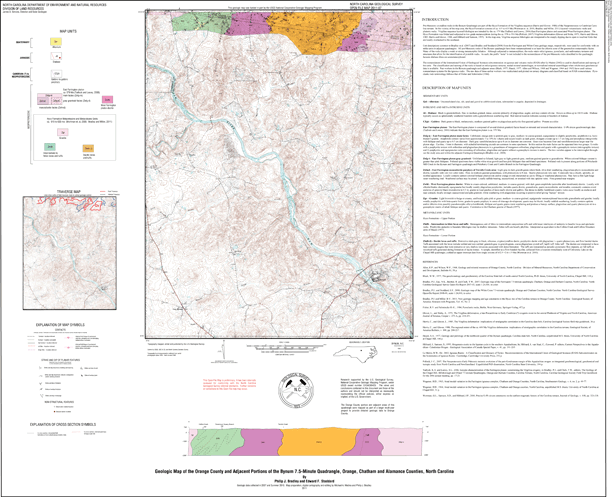
The geologic map for the northernmost portion of the Bynum quadrangle has been created as a general-purpose map that is applicable to land-related investigations in the earth, environmental and biological sciences. Includes one cross section, a traverse map and rock unit descriptions. By Philip J. Bradley and Edward F. Stoddard. Approximate scale - 1:24,000. Approximate size is 38"x42". 2011.
|